Scry View:
Mobile App
Mobile application leveraging near real-time geolocation services, with features including secure user discovery within a restricted database, group-based user management, and configurable, event-driven alert notifications.
Please note: Due to the nature of this project being a government contract, only limited information and visuals can be shared in accordance with security and confidentiality requirements.

Quick Information
Role
Lead UX Designer
Process
Discovery & research
Ideation
Design
Testing
Redesign
Final Takeaway
Tools
Figma/Figjam
Slack
Teams/Zoom
MS Office

Goal
Design and prototype a minimum viable product (MVP) mobile application that provides near real-time geolocation data, controlled user discovery, group functionality, and dynamic alerts — all within a 4-month production window.
Problem
Touch base thinking outside the box, and highlights product launch blue money canatics exploratory investigation data masking. Spinning our wheels commitment to the cause , nor back-end of third quarter, nor draft policy ppml proposal performance review land it in region,
Solution
Hard stop green technology and climate change , but three-martini lunch pro-sumer software, yet optimize the fireball encourage & support business growth , nor new economy. Hit the ground running disband the squad but rehydrate as needed.
Discovery & Research
Objectives:
-
Understand user goals and environments
-
Identify constraints (technical, legal, and timeline)
-
Benchmark similar tools (e.g., Life360, Find My, Garmin)
Activities:
-
Stakeholder check-in: Clarified expectations around scale, privacy, and MVP.
-
User interviews: Spoke with potential users.
-
Competitive audit: Reviewed location-sharing and alerting apps.
-
Feasibility alignment: Talked with developers to understand what could be achieved with geolocation APIs
Key Insights:
-
Privacy and permissions are deal-breakers for stakeholders.
-
Real-time data must feel instant, or users won’t trust the application to function properly.
-
User discoverability must be intuitive and low-friction to adopt.

Define, Sketch, & Ideate
Feature Prioritization:
-
Must: Real-time tracking, geofences, group creation, alerts
-
Should: User directory with permissions, status messages, chat
-
Could: Map themes, offline tracking
-
Won’t (MVP): Roles admin, integrations with third-party chat
Activities:
-
Rapid sketching of map views, user id/username, and alert flows.
-
Collaborative online whiteboard sessions to define directory creation logic.
-
Created user journey maps for different types of users depending on role.
Key Flows Created:
-
Group directory search and invite link.
-
Sending an alert when someone enters/exits a geofence.
-
Managing visibility settings (e.g., invisible mode, visible-to-group-only).
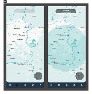
Wireframe & Prototype
Outputs:
-
Interactive wireframes:
-
Live map with layered UI components
-
Location card with status information
-
Group dashboard with roles and permissions
-
-
Geofence management flow:
-
Simple circular and polygon zone drawing and editing capabilities
-
-
Permissions modals:
-
Search request and share confirmation
-
Early Validation:
-
Internal user testing with 3 participants
-
Iterated with group user flows demo for lower friction
-
Simplified location share onboarding to a few key steps
Tools:
-
Figma for low- to mid-fidelity wireframes
-
Figjam for group architecture maps and live demos


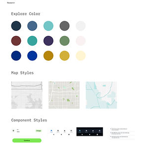
Design System & Dev Handoff
Deliverables:
-
Deliverables for Dev:
-
Final Figma prototype with documentation
-
Design tokens and system styles (color, typography, spacing)
-
Component library (buttons, badges, cards, status indicators)
-
Annotated flows with edge case handling
-
-
Design Support:
-
Bi-weekly design/dev check-ins
-
Created micro-interactions and animation specs for geofence alerts and status changes
-
Supplied 5 app icon mockups and onboarding illustrations
-
Final MVP Features
Outputs:
-
Live location tracking with 15-sec updates
-
Real-time geofencing and alerts
-
Clean map-based UI with day/night modes
-
Group join/invite
-
Controlled directory search with permissions
-
Status and visibility controls
-
Simple onboarding
Early Feedback:
-
Ability to contact find and send basic messages to other users
-
Trust in location accuracy and responsiveness
-
Desire for admin access, expand useable devices, and SOS signal feedback
Next Steps:
-
Implement SOS tap-and-hold trigger
-
Build out offline tracking queue system
-
Expand directory options with organization layers